
今回私たちが出会ったのは、1800年、江戸時代後期の三島のまちです。現在の町名とは異なる名前で区間を分けられていた当時のまちの面影を探し、たどってみましょう。
For this volume, we travel back to Mishima Juku (post station) in the year 1800 to discover remnants from a time when the region was divided into towns with distinct features and names quite different from today.
Note: The words Cho and Machi both mean 'Town'.
裏町 ( うらまち・現 大宮町 / 中央町 )
三嶋大社境内にある祓戸神社、 通称浦島さんに繋がっていたため「浦町」とも呼ばれていました。鎌倉古道沿いでは、当時の面影の静けさを感じることができます。
Uramamachi (Currently Omiyacho, Chuocho)
Haraido Shrine located inside the grounds of Mishima Shrine was also known as Urashima San, lending its name to the town. Walking along the Kamakura Kodo today, we can still feel the tranquility of those days.
三嶋大社、祓戸神社から西へ伸びる鎌倉古道
久保町 ( くぼちょう・現 中央町 )
三島宿の中でもっとも低く、窪んでいる土地であることから、窪=久保町と名が付けられたと言われています。当時まちの物流の拠点であったこの場所に、現在は郵便局が建っています。
Kubocho (Currently Chuocho)
The word Kubo is a low-lying area, and as this town sits in one of the lowest-lying areas of the region, 'Kubocho' was a fitting name. Once a distribution center for the area, today a large post office now serves this role.
大中島町 ( おおなかじまちょう・現 本町 / 南本町 / 広小路町 )
源兵衛川と四ノ宮川の二つの川に挟まれた、大きな中の島だったことから「大中島町」という町名になったそう。今でも商店が軒を連ね、三嶋大社への参拝客や地元の人々で賑わっています。
Onakajimacho (Currently Honcho, Minamihoncho, Hirokojicho)
Directly translating to large island town, the name is derived from the fact that the area lies between the Genbe and Shinomiya Rivers, resembling a large island within the city. Still today, the streets in this area are crowded with visitors and locals alike.
小中島町 ( こなかじまちょう・現 本町 / 南本町 )
大中島に対し、四ノ宮川と御殿川に挟まれた、小さな中の島だったことからこの名で呼ばれた「小中島町」。樋口家と世古家の本陣が、街道を挟む形で門を構えていました。
Konakajimacho (Currently Honcho, Minamihoncho)
This 'island' area is bordered by the Shinomiya and Goten Rivers and is smaller than the neighboring Onakajimacho. On its main street stood large intricate gates that guarded the entrance to two Honjin* owned by the Seko and Higuchi families.
*Large residences officially designated as accomodations for government officials and feudal lords during the Edo period.
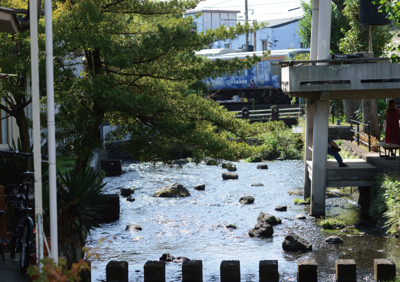
昔から変わらない風景、源兵衛川
伝馬町 ( てんまちょう・現 大社町 / 日の出町 )
佐野街道と下田街道の分岐であるこの場所に、駅伝馬が置かれていたことから「伝馬町」と呼ばれ、100疋の馬が置かれていたといいます。
Tenmacho (Currently Taishacho, Hinodecho)
This town was the center of transportation and trade and located at the intersection of the Shimoda and Sano Highways running south and north from Mishima. It is said that this area housed 100 horses and 200 men engaged in the shipping and transport of official documents, passengers and freight.
新町 ( しんまち・現 大社町 / 日の出町 )
江戸時代初期、東海道の宿駅制度が始まった際新たに作られたと言われているまちが「新町」です。悠々と流れる大場川にかかるこの橋から臨む端正に聳える富士の雄姿は、当時から変わらぬ景色です。
Shinmachi (Currently Taishocho, Hinodecho)
As the word Shin (new) implies, this town was newly established on the eastern edge of Mishima Juku at the start of the Tokaido post system early in the Edo period. From the bridge that crosses the Daiba river into the town center, we can see the same stately view of Mt. Fuji that people have observed here for centuries.
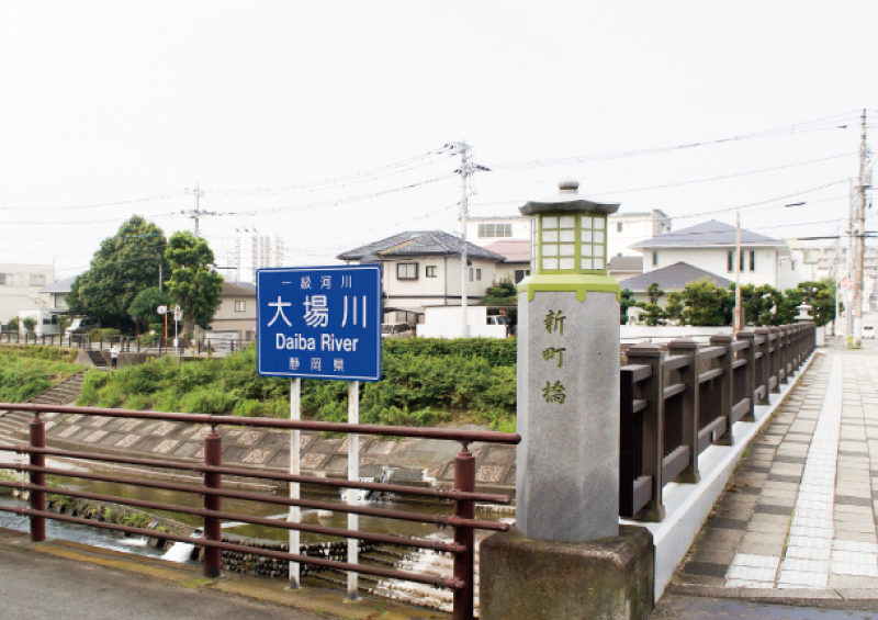
大場川にかかる新町橋を通り、旅人は三島へ入りました。
茶町 ( ちゃまち・現 西本町/栄町/緑町/西若町 )
茶屋が立ち並び、旅人の疲れを癒した茶町。三島から伊豆に掛けての名産を、当時の人々も味わっていたのでしょうね。
Chamachi (Currently Nishihoncho, Sakaecho, Midoricho, Nishiwakacho)
This area was home to numerous teahouses where weary travelers could rest and enjoy local delicacies, much like they do today.
柴町 ( しばちょう・現 芝本町/本町/一番町/寿町 )
「柴町」は町域にある長圓寺が、芝増上寺の末寺であったことが その名の由来とされています。また、雑木林が多い地域であったことから、江戸時代の文献には"柴"の漢字が充てられています。
Shibacho (Currently Shibahoncho, Ichibancho, Kotobukicho)
This town derives its name from the fact that the temple located there, Choenji, was a related temple of Shiba Zojoji located in Edo. The name also refers to the thickets (shiba) growing in the area.
蓮行寺町 ( れんぎょうじちょう・現 泉町 / 栄町 / 広小路町 )
蓮行寺(現・伊豆国分寺)が創建された際に、寺の名前をとって名付けられたと言われています。その後、蓮行寺町は国分町へ寺の名前の改名とともに改称されました。
Rengyojicho (Currently Midoricho, Sakaecho, Hirokojicho)
This area was so named after Rengyoji Temple (currently Izu Kokubunji Temple) was constructed. The temple was later renamed Izu Kokubunji Temple, with the town also renaming itself Kokubuncho.
茅町 ( かやまち・現 加屋町/栄町/清住町 )
「茅町」の西側の境川の周辺が低い湿地帯となっており、茅が多く生えていたため名付けられたと言われています。
Kayamachi (Currently Kayamachi, Sakaecho, Kiyozumicho)
The area surrounding the Sakai River on the western edge of the city was a low-lying wetland where plants used for thatch (kaya) could be found.
六反田町 ( ろくたんだちょう・現 広小路町/泉町/西若町/寿町/緑町/南町 )
当時、この地に六反歩(6キロ平方メートル)もの田んぼが開墾されたことを印象付ける名前の「六反田町」。田んぼが広がる三島のまちを、ぜひ想像してみてください。
Rokutandacho (Currently Hirokojicho, Izumicho, Nishiwakacho, Midoricho, Minamicho)
On your next walk through this suburban area of the city, imagine it was once covered by a large rice field measuring 6㎢, hence the name that translates to exactly that.
田町 ( たまち・現 北田町/南田町/中田町/中央町/富田町/南二日町 )
田畑を多く有する湿地帯が広がり、農業を営む人々が集まることでできたのが「田町」です。
Tamachi (Currently Kitatamachi, Minamitamachi, Nakatamachi, Chuocho, Tomitamachi, Minamifutsukamachi)
As people began to inhabit this region defined by rice fields and low-lying wetlands, it was given the name Tamachi.
市ケ原町 ( いちがはらちょう・現 大社町 )
現在の大社町に当たる「市ケ原町」は、市が開かれ人で賑わう、旧下田街道沿いに位置しています。
Ichigaharacho (Currently Taishacho)
Located along the Old Shimoda Highway, this area was often crowded and hosted a local Ichi or market.
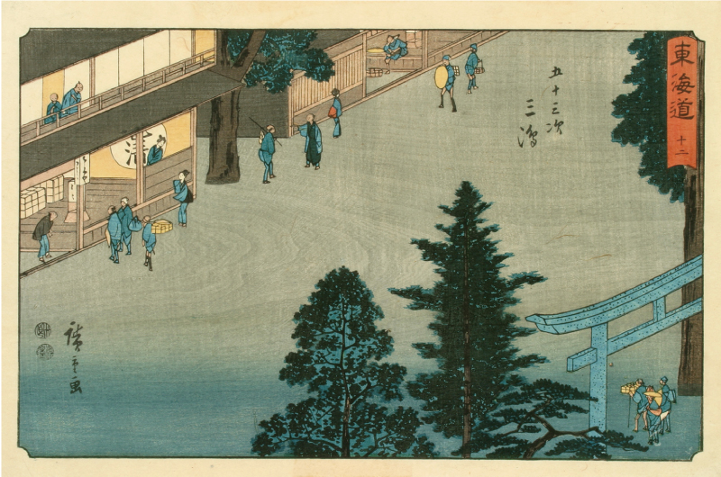
歌川広重「東海道十二 五十三次三島」には三嶋大社前に広がるまちが描かれています。
三島市郷土資料館提供
二日町 ( ふつかまち・現 大社町/東町/東本町 )
市ケ原町に同じく、三嶋大社前に栄えた 「二日町」では、毎月二日に市が立っていたことからこの名が付けられたと言われています。市の習慣は、近世初期頃まで続いていたそうです。
Futsukamachi (Currently Taishacho, Higashicho, Higashihoncho)
Similar to Ichigaharacho, this was a prosperous area located near Mishima Shrine. A market was held here on the second of each month, a custom that continued into the modern era.
金谷町 ( かなやちょう・現 大社町 )
三嶋大社の近くに位置する「金谷町」には、鍛治職人が居を構え、刀を打ったり馬蹄を仕上げたり、宮大工に必要な金物などを作っていたそうです。
Kanayacho (Currently Taishacho)
Kanaya which translates to 'metal valley' was a town that derived its name from the concentration of smiths who constructed armor and forged swords and horseshoes in the area.
木町 ( きまち・現 西本町/栄町/西若町/緑町 )
木町には、木賃宿(燃料代である薪の代金で泊まらせた素泊り宿)がありました。また、三嶋大社で必要な木材を手配する木屋(材木の売買をする人)や工事を請け負う木匠(木材を使い家屋などの建築や修理をする人)が多く住んだと言われています。
Kimachi (Currently Nishihoncho, Sakecho, Nishiwakacho, Midoricho)
Kimachi (wood town) was known for its kichinyado*, woodworking shops and lumber yards that prepared timber for Mishima Shrine.
*Facilities offering lodging where no food was served and payment for stay was often paid in firewood.
宮倉町 ( みやぐらちょう・現 大社町/東本町/日の出町/東町 )
三嶋大社の南側には蔵が建ち並ぶ一角があり、古くは「倉町」という地名も残っています。 三嶋大社周辺で収穫された穀物が貯蔵されていたそうです。
Miyaguracho (Currently Taishacho, Higashihoncho, Hinodecho, Higashicho)
This area south of Mishima Shrine (miya) was once lined with storehouses (kura) and was where the rice harvest was kept.
長谷町 ( ちょうやちょう・現 大社町 / 日の出町 )
名前の由来には諸説あるとされています。① 伊豆国府の「庁舎」が訛った ②長者が住んでいた ③ 源頼朝の三嶋明神参拝に関わった在庁の屋敷跡てがあったことなどが挙げられています。
Choyacho (Currently Taishacho, Hinodecho)
There are several stories as to the origins of this name. One suggests that the pronunciation of the provincial government building in Izu, known as a Chosha, shifted to become Choya.